Like a lonely whale song, a single repeating ping echoes in the deep Indian Ocean. Somewhere in this vast watery wilderness lies the black box of Malaysia Airlines Flight MH370, with its battery-operated pinger slowly losing power.
The pinger is small and the echo must travel through miles of ocean which slowly saps its strength, its call fading dramatically as it reaches for the surface. Waterlayers of different temperatures bend sound waves in a process known as refraction, trapping echoes in deep water layers or bending them away from listening devices. Even with today’s most sophisticated listening devices, the odds of being close enough to hear the pinger are as remote as seeing a candle two miles away in the fog.
Much of the media focus has been on the pinger, but locating the debris field is the first necessary step, only then can the search area be determined, followed by the deployment of sophisticated sub-surface technology. Based upon the success rate of relocating debris spotted by satellites, the pinger will be long dead by the time authorities narrow down the search zone.
 Experts indicate if the debris field isn’t found before the pinger dies, all hope is lost. This makes for a very dramatic storyline. Nonsense. Yes, it might have taken almost two years to locate the black boxes from Air France Flight 447, but searchers were still able to find the pinger long after it had stopped sending out its signal.
Over the past 30 years, I have been involved with teams who have searched for sunken aircraft and never once did the pinger locator tell us where to find the aircraft. Pinger locators work well in shallow water and if searchers know the local vicinity of the crash. In large, deep search areas the size of Poland or New Mexico, they need to primarily be looking for surface debris to narrow down the search area. Once definitive debris from the wreckage is found, then with or without the pingers, the main debris field on the sea floor can be located.
Spotting debris on the ocean surface is difficult enough in flat, calm conditions. Add three or four meter seas and white caps, and debris becomes extremely difficult to see. Even with the most sophisticated satellite capabilities, until a surface ship has recovered and identified a piece of the aircraft, the general impact area cannot be calculated.
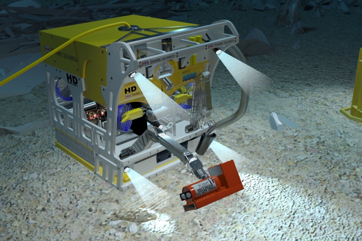
After the search team collect numerous pieces of wreckage, they will use sophisticated computer programs to input each piece’s position, as well as the weather conditions that have occurred since the crash. The aircraft information parameters such as satellite communications, fuel burn, etc., will also be combined to create a search probability matrix. Then each square mile of sea floor will be searched utilizing sophisticated bottom-imaging sonars.
The aircraft will be found if there is enough funding to keep the search moving. However, inclement weather will reduce the operational time of the search teams and the hunt will become a tedious, long drawn-out process, just as it was with in the Air France Flight 447 investigation. It is already becoming even more challenging because of the onset of winter in the southern hemisphere winter. Regardless, given enough time and support, the wreckage can and most likely will be found with or without the pinger locators.
In our next post, we will discuss the amazing sonar systems that will be used to locate aircraft debris on the ocean bottom.
Vincent J. Capone, M.Sc., is an expert in undersea search operations, has been a long-time sonar instructor for the U.S. Navy and also provides his expertise to commercial customers worldwide. He was a member of the Apollo F-1 engine recovery team who recovered F-1 rocket motors from over 14,000 feet of water in March of 2013. Mr. Capone has worked for the U.S. Navy Supervisor of Salvage and played a role in the search for the Space Shuttle Columbia debris in two Texas reservoirs.
© Copyright 2014 Vincent Capone